Oregon Chapter
8th Air Force
Historical Society
Preserving the history of the Mighty 8th
World War Two Memories Project
Lawrence Fick
Lead Navigator 458 BG(H) Bomb Group 752 Squadron
Documents in PDF; map images are in JPG format. Video is either MPG or WMV. All images and video is posted onto the web at reduced resolution. Higher quality versions can be purchased from the chapter.
How Maps were used in the European Theatre
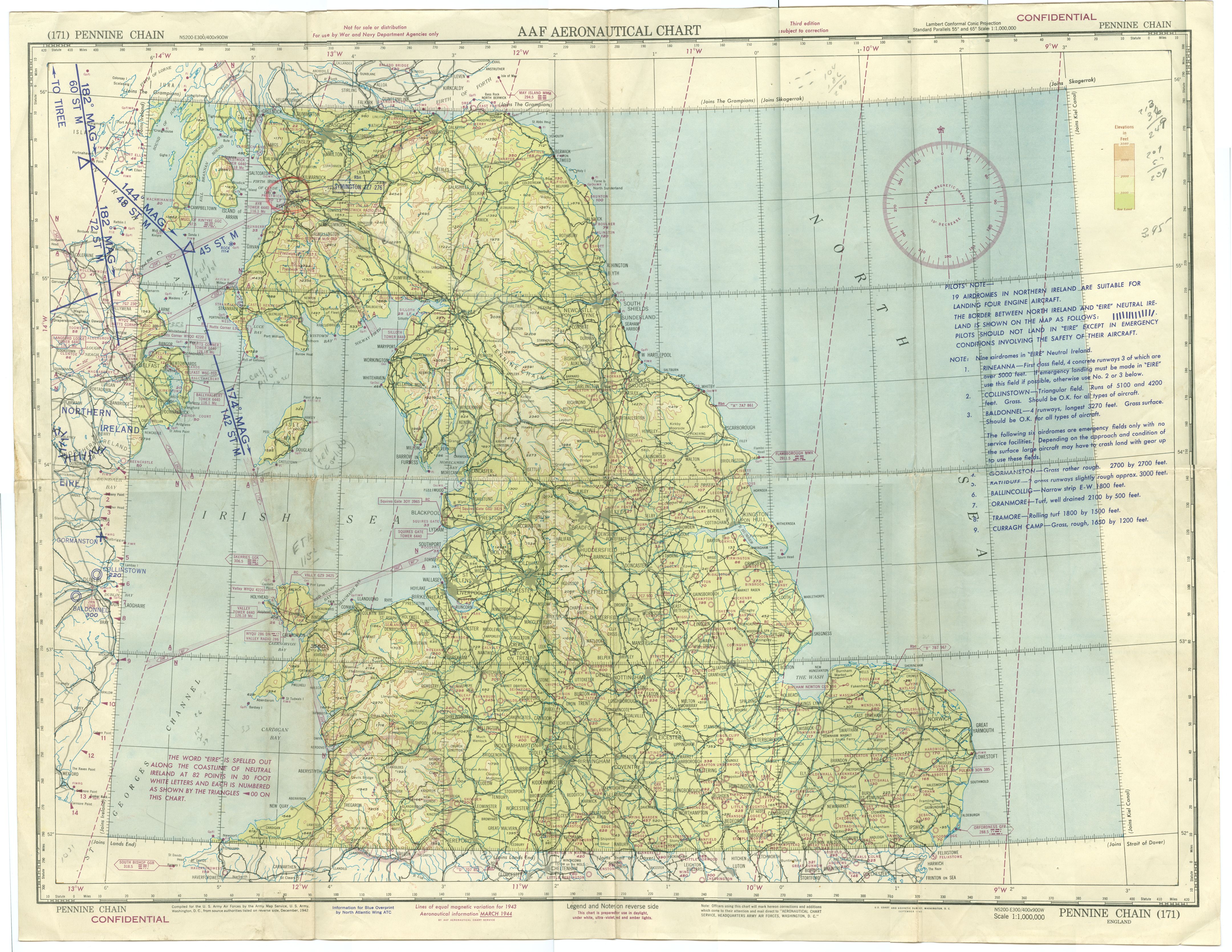
Pennine Chair maps (a series of maps that covered England). We did not use them after we arrived at Valley Wales. They were issued to us at Iceland and we were to go down to the Irish Sea and then go to Valley, Wales. We left Iceland after a break in the weather and soon were over a heavy cloud formation. After we got down to what I assumed was land I asked the pilot to let down through the clouds and see what was down there. We broke out over Bangor harbor that was filled with a convoy gathering to cross the North Atlantic. The war ships were all flashing the code ofthe day. Our Aldis lamp was under some of our gear and I told the pilot to go back up into the clouds, quick. We eventually arrived at the Valley Air field and landed. We were told, get your gear out the plane, it is no longer yours.
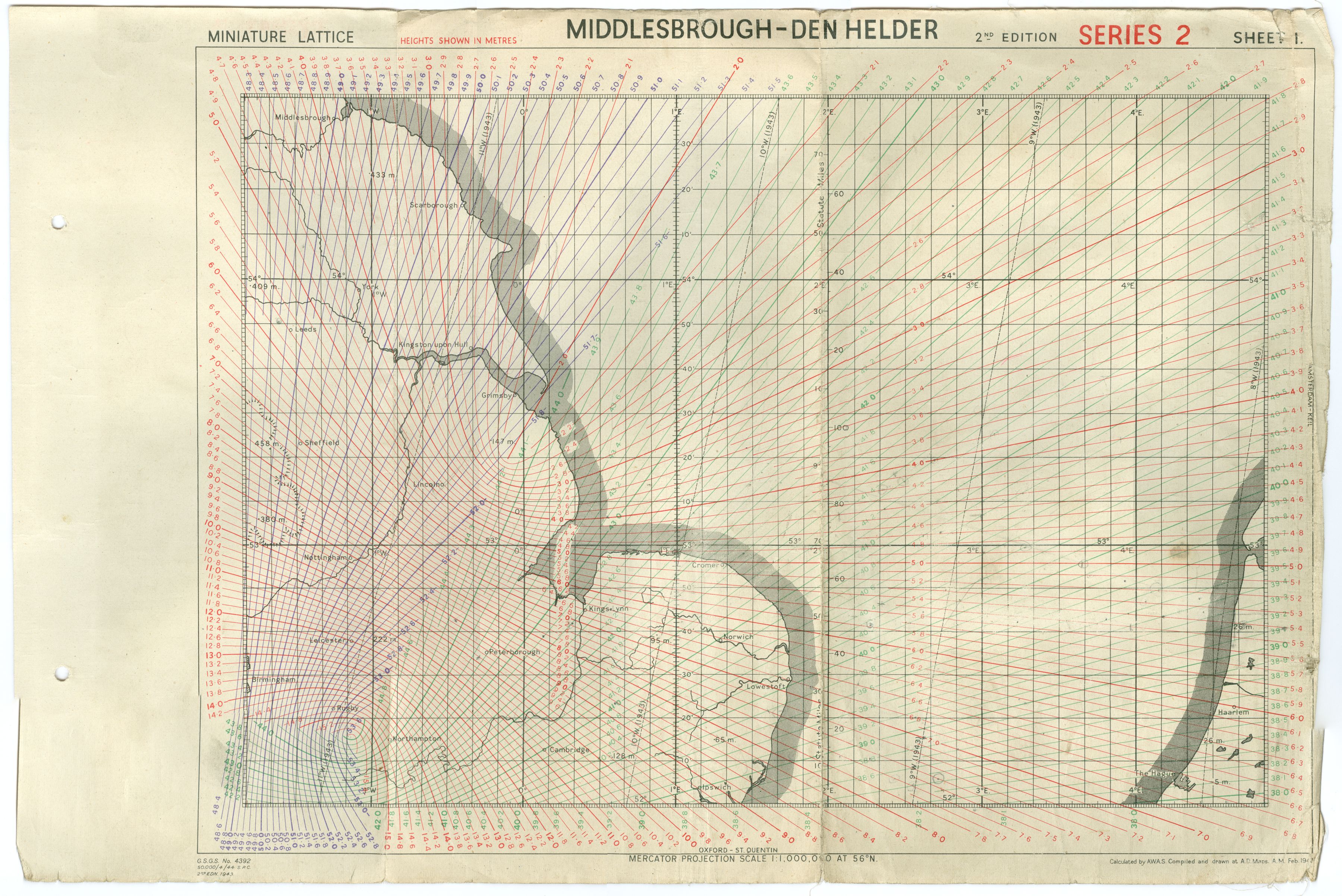
Middlesbrough-Den Halder. These durable maps were used for finding our way around England. They stood up to a lot ofwriting and erasing. There were a number of Gee navigation systems made up of master stations that would send out a signal and slave stations would trip and send out a signal. The result was two lines of green across a cathode ray tube. When you could make the blips stop moving you would lock it in and transfer the numbers to the map. That was your position when you locked it in. The system was very accurate over England and on the west coast of the continent. As you got farther east it became harder to use. We even used it for bombing near the coast. Lead crews had to take up the ship that they were going to use the next day. We would use the time to practice using the Gee box to find our base and the two large bases near the channel as ifwe were in heavy fog. We had a system called Fido at our base made up of lines of smudge pots along the run ways that could be ignited and bum offthe fog along the run way. Our problem was to get close enough to see that line of pots.
Strasbourg, Berlin, Straight of Dover. I heard that when the war started the navigators had to use National Geographic maps to find their course. I don't know ifthat was true or not. When I got there they had excellent maps. The dark green shapes on the maps are "forests". In that area they apparently down cut down the trees and plant crops. The shapes were so distinctive that we could navigate by them. The roads, streams, and villages were also very accurate. As to shape and location.
WWII Aerial Maps Explained PDF version of above text.
Sample Aerial Maps
- AAF Map 171 Penne Chain This is a map created by the AAF using the world grid identification method. Not used other than to get to England by AAF crews. March 1943. Scale is 1:100,000,000
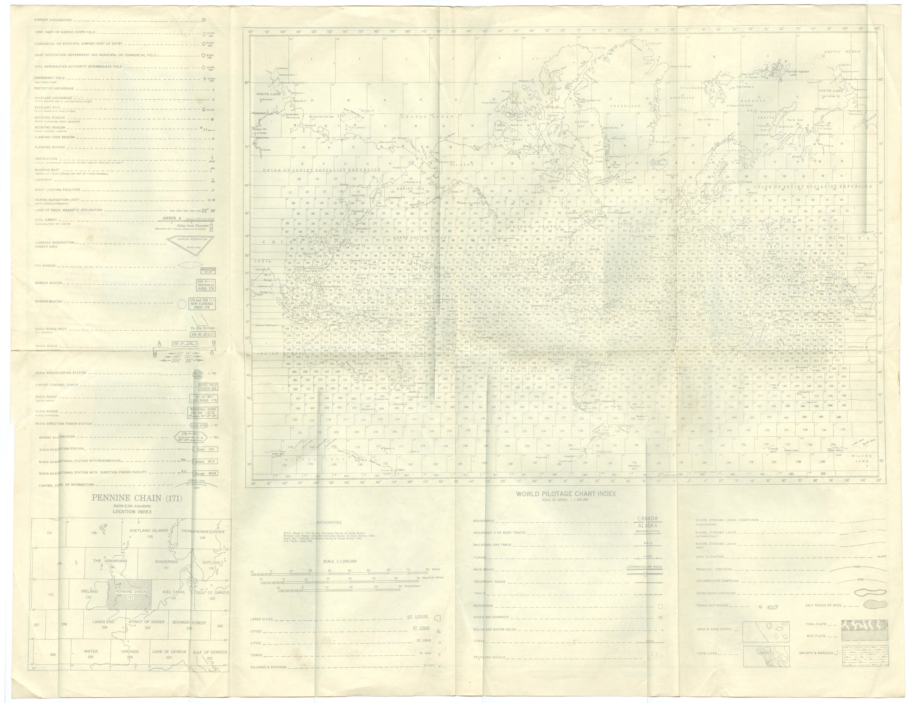
- World Map Grid map identification. This is on the back side of the Pennine Chain AAF map. Shows all the map number to use when over that section of the globe.
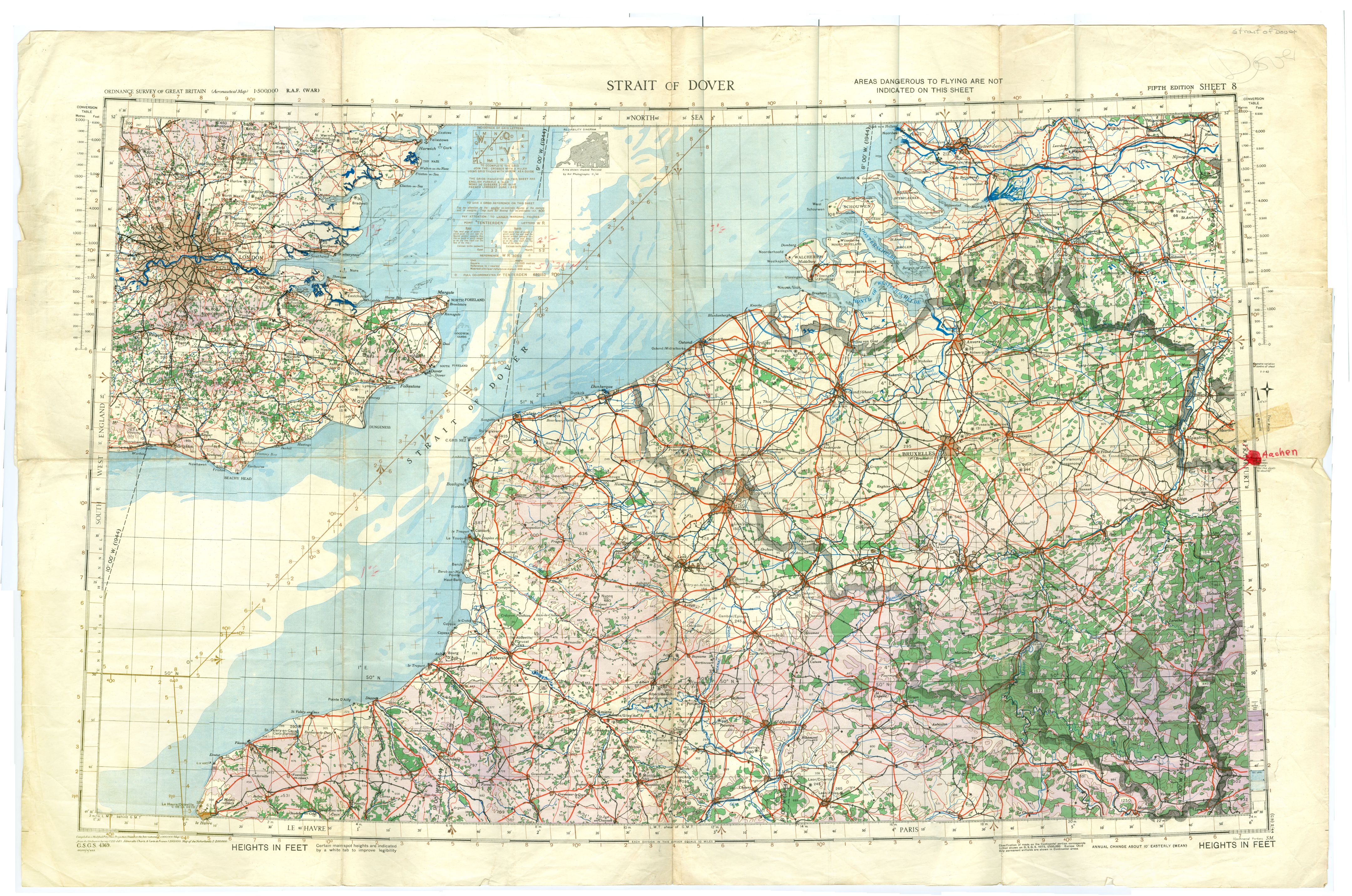
- Straight of Dover RAF based maps were used by USAAF crews while in Europe to ensure that everyone flew with the same set of navigation data. 1:500,000 scale, Fifth edition, Sheet 8, aeronautical map. February 1944. All heights are in meters.
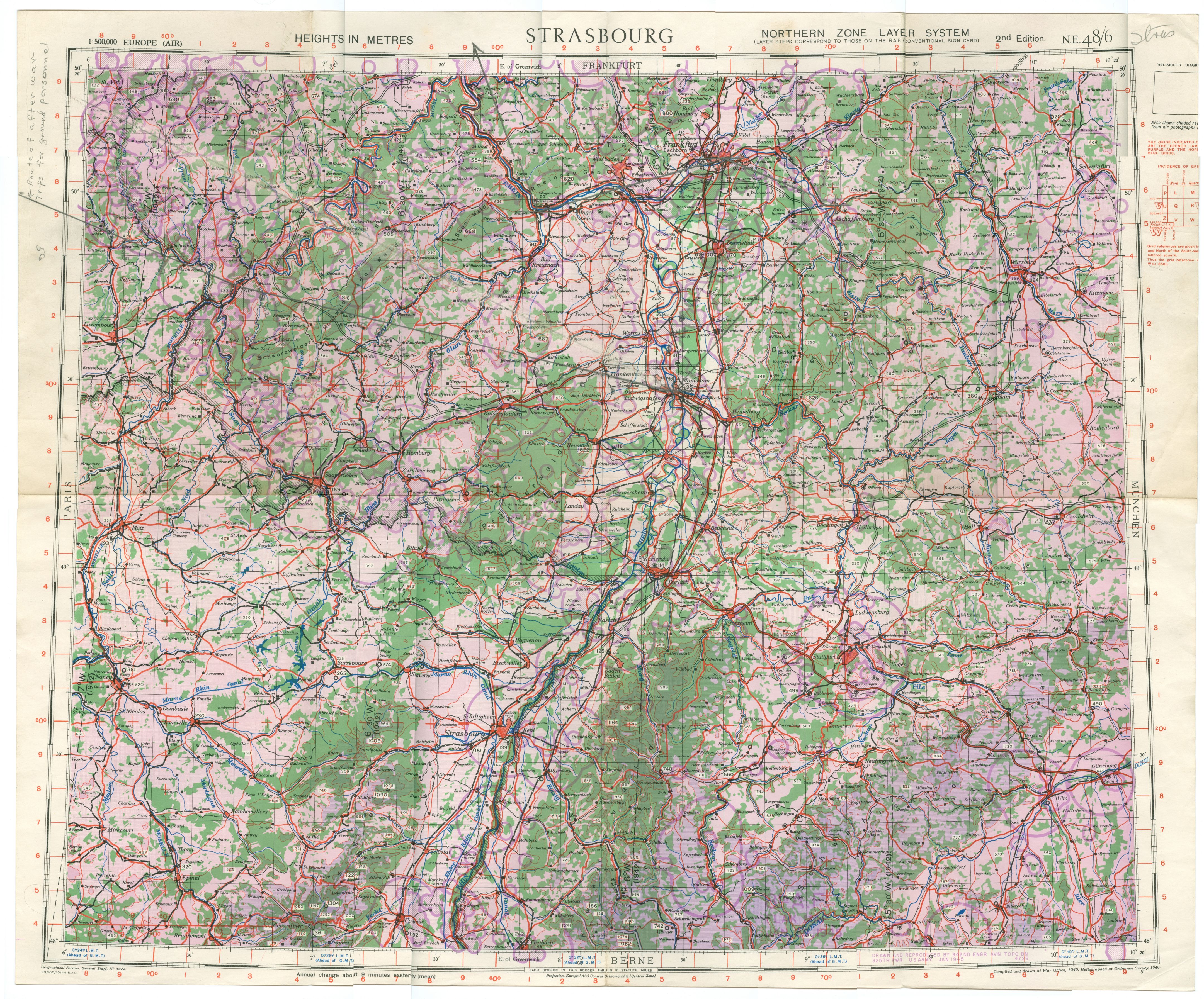
- Strasbourg aeronautical map 2nd Edition January 1945. 1:500,000 scale map. Shows the mission route flown by Lawrence Fick when taking ground personnel over a tour of Germany after the war.
- Middlesbrough-DEN Helder Gee map 2nd edition Series 2 Sheet 1. Gee was a radio navigation method used to locat and bomb targets when clouds prevented visual bombing. Maximum range of GEE was 180 miles. Ability to use varied according to where the transmitters were located in comparison to where you were at. When aligned almost parallel to each other it could not be used. Best when at 90 degrees to each other.
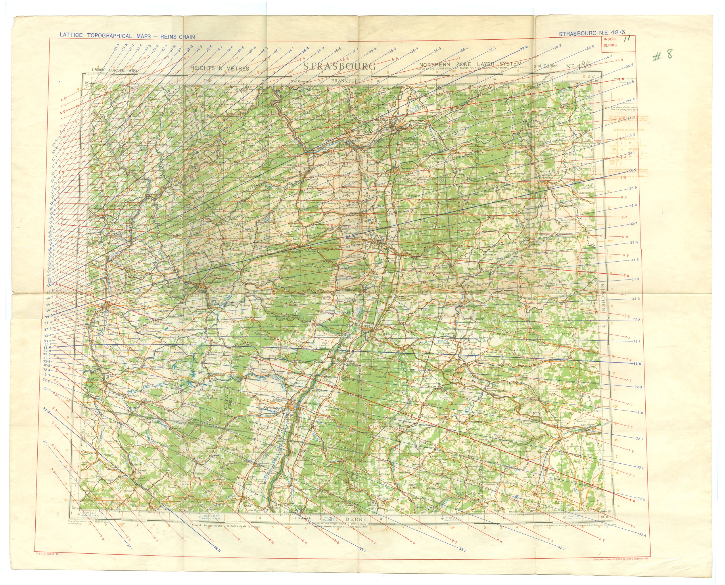
- Strasbourg Reims Chain GEE This is a Lattice Topographical map Reims Chain section. Showing the Gee lines in blue and red overlaid over a 1:500,000 scale aerial map. Labeled Strasburg N.E. 48/6. General staff map 4072. printed in October 1944.
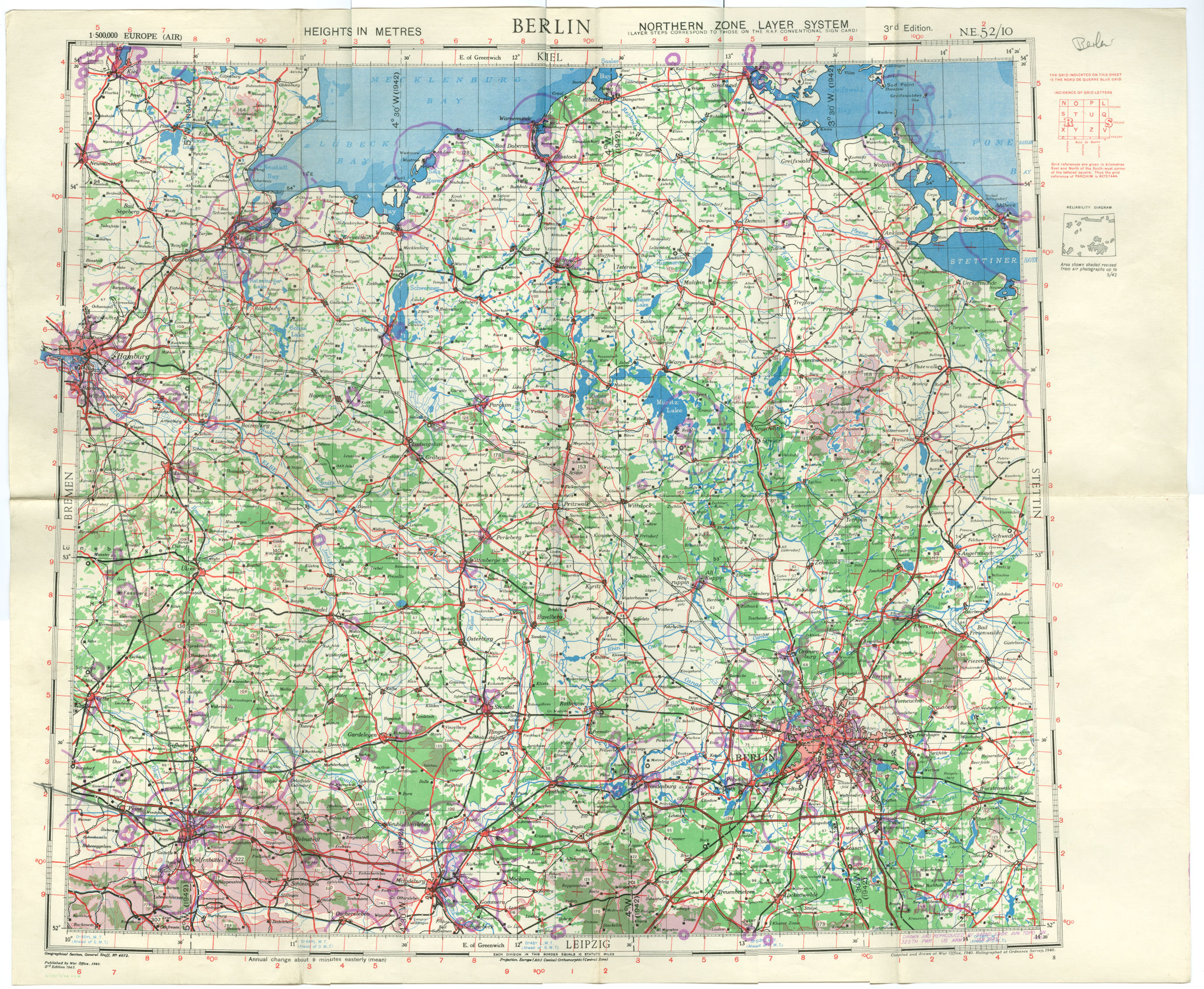
- Berlin Aerial Map 3rd Edition 1943. map Labeled N.E. 52/10; scaled at 1:500,000 using the Northern Zone Layer System of the RAF. Each map has along each of the 4 edges the names of the maps that are next to them. South map would be Leipzig, east map would be Stettin, north map Kiel, and west map would be Bremen.
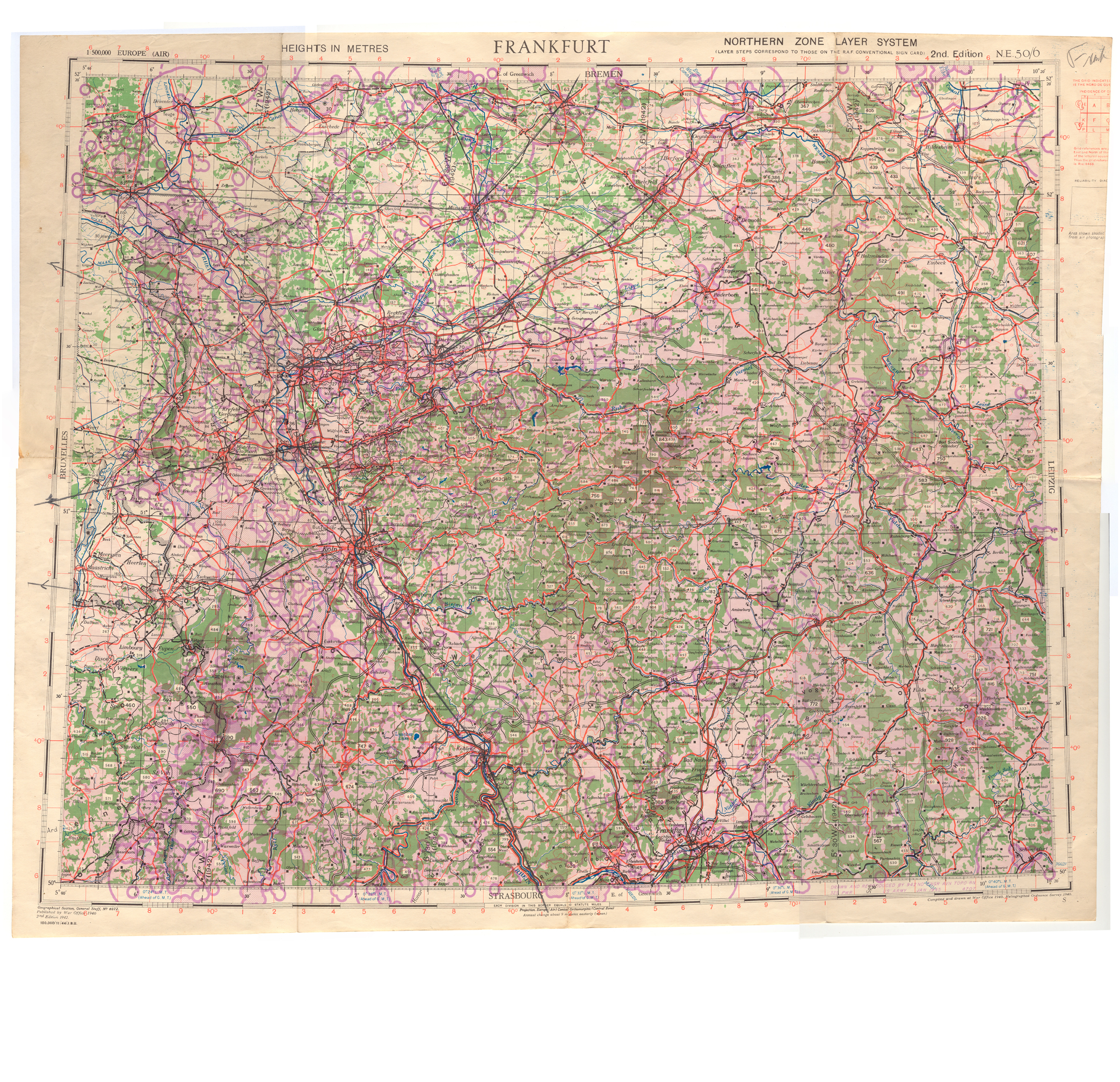
- Frankfurt Map showing flak areas around targets / cities. Each purple circle around an area shows that at altitude - 25,000 feet - you can expect flak to be fired at you. Map dated 27 January 1945, 2nd Edition N.E. 50/6. Map west would be Leipzig, north is Berlin, west is Bruxelles, and south is Strasburg.
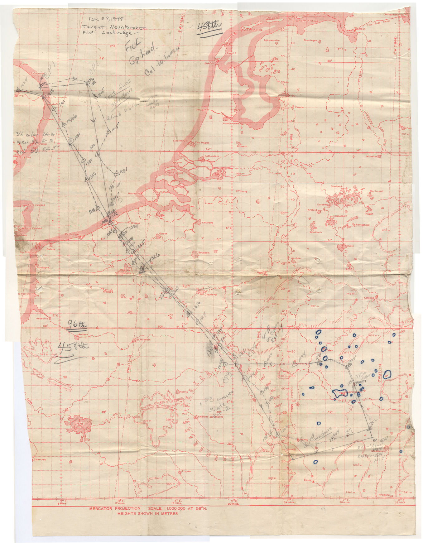
- Flak Planning Map showing the route that he flew when the group bombed Neunkirchen on December 27, 1944.
Lawrence Fick Documents
Lawrence R Fick WW II Narrative - A Farm Boy from Oregon
- 2nd-Lt-George-Koehn-0-699679.pdf
- 2nd-Lt-James-A-Soesbe-0-716983.pdf
- 458-BG-all-three-Sqadrons-formation-at-base-after-raid.pdf
- 458-BG-an-Assistant-lead-navigator-1945.pdf
- Capt-John-W-Moran-B-24-458-BG.pdf
- Absense-card-April-3-1944.pdf
- Aerial-Naviation-maps-explained.pdf
- Aircrew-person.pdf
- Aviation-Cadets.pdf
- B-24-458-BG-Micky-radar-PPF-ship-code-J3-02.pdf
- B-24-458-BG-Micky-radar-PPF-ship-code-J3.pdf
- B-24-9100.pdf
- B-24-formation-SN-188340-two-others-drop-napalm.pdf
- B-24-High-Squadron-overhead.pdf
- B-24-Hollywood-and-Vine-nose-art-02.pdf
- B-24-Micky ship-755th-SQD-358-BG-over-Horham-St-Faith.jpg
- B-24-Navigator-752-Sqd-458-BG.pdf
- B-24-Shack-Time-sn-440275-Code-J4.pdf
- B-24-SN-1250912-bombs-away-over-Germany.pdf
- B-24-SN-295165.pdf
- B-24-SN-128349-follows-napalm-drop-in-France.pdf
- B-24-with-thrown-number-3-prop-damage.pdf
- Group Photo Bickleigh-castle-Devon-10-Nov-1944.pdf
- Cadet-Lawrence-Fick.pdf
- Capt-John-Jack-Moran-final-pilot.pdf
- Capt-Lawrence-Fick-at-barracks.pdf
- Crewman-2-Moran-crew.pdf
- Crewman-Moran-crew.pdf
- Eddie Gneokowski-Bob-Stoessor.pdf
- ETO-Planning-Map-in-Hanger.pdf
- Flak-Zone-Sample.pdf
- Hamburg-2009.pdf
- Hamburg-Germany-1945-01.pdf
- Hamburg-Germany-1945.pdf
- Hollywood-and-Vine-nose-art-01.pdf
- Horsham-St-Faith-Airfield-June-1945-Station-123.pdf
- Horsham-St-Faith-June-1945-Station-123.pdf
- Capt-John-Moran-AT-6.pdf
- Lawrence-Fick-news-articles.pdf
- Lawrence-Fick-Squadron-over-Germany.pdf
- Lawrence-Kansas-graduatrion.pdf
- Lead-Crew-Commendation-24-Feb-1945-458-BG.pdf
- Lionel-and-Friend-Cambridge-cemetery-Aug-1990.pdf
- Lionel-Horsham-St-Faith-1944.pdf
- Lt-Larry-Fick.pdf
- Mission-Navigator.pdf
- Moran-B-24-one-of-ships-flown.pdf
- Officer-at-desk.pdf
- Pilot-and-friend.pdf
- Pilots-their-names.pdf
- Pilots.pdf
- Sgt-Anthony-J-Corlite-31203718.pdf
- Squadron-Navigator-Lawrence-Fick.pdf
- SSGT-Merlin-T-Ash-39278839.pdf
- Stike-photo-Hamburg-Germany.pdf
- Stike-photo-Neunkirchen-military-German-target.pdf
- Stike-photo-Unknown-German-target-02.pdf
- Stike-photo-Unknown-German-target-03.pdf
- Stike-photo-Unknown-German-target.pdf
- Strike-Photo-Berlin-Germany-2.pdf
- Strike-Photo-Berlin-Germany.pdf
- Strike-Photo-Kitzingen-airfield.pdf
- Strike-Photo-Mourmelon.pdf
- Strike-Photo-Rastatt-Germany.pdf
- Strike-Photo-Regensburg-Germany.pdf
- Trafalgar-Square.pdf
- Unknown-B24-postwar.pdf
- Norwich Castle A photo of the Norman castle in the centre of the city of Norwich, Norflok ,England , the road which curves round to the left of the castle is known as "Castle Meadow" and the triangular area to the right of the castle is the old "Agricultural cattle and stock market", which is a large underground shopping mall.